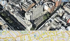
In a UK-first, the photo-realistic 3D maps were created from actual film footage shot from light aeroplanes using sophisticated aerospace technology, which is then merged with other film taken from ground level.
They can be used for free on the Yell.com website, which is the online version of the Yellow Pages directory.
Said Matthew Bottomley, who heads up innovations at Yell.com: "If Superman needed a plumber in Paddington in a hurry, he could now plan his flight on Yell.com.
"It's a fascinating opportunity to view your city from a different angle - as well as a brilliant new way to see exactly where you're going, before you leave home or the office.
"We all know that ordinary maps tell only part of the story. You can be right around the corner from the shop or restaurant you're trying to find, and not realise it's just over the nearest rooftop. Now you can actually look down and around from every angle from that very rooftop.
"It's all part of Yell's mission to perfectly match up local businesses with their local customers, so everyone gets just what they need."
So far, Yell has created 3D maps of Birmingham, Leeds, London and Manchester. More regions will get the 3D treatment as the concept rolls out around the country.
Have a fly at https://www.yell.com/maps

Adland® is a commercial-laden heaven and hell for advertising addicts around the world.
This advertising publication was founded in 1996, built on beer and bravery, Adland® now boasts the largest super bowl commercials collection in the world.
Adland® survives on your donations alone. You can help us out by buying us a Ko-Fi. Adland® works best in Brave browser